


By KK Chatradhara
On May 31, 2025, a catastrophic flash flood struck Assam’s Lakhimpur district, triggered by an excessive discharge from the Ranganadi River. The flood inundated 243 villages, claimed the lives of Biren Pawe and Rajkumar Taid in Nowboicha Revenue Circle, and caused extensive damage to infrastructure, agriculture, and livelihoods. This report integrates data from the 2008 flood and the 2017 IIT Guwahati study to analyze the causes of the 2025 flood and assign responsibility for the downstream devastation.
The primary trigger was the North Eastern Electric Power Corporation’s (NEEPCO) release of excess water from the 405 MW Panyor Hydro Electric Project (PHEP), compounded by heavy monsoon rainfall, recurrent embankment failures, and ongoing environmental degradation. Historical floods in 2008 (695.20 cumecs, 22 deaths), 2017 (1,412.57 cumecs), and incidents between 2009 and 2015 highlight persistent vulnerabilities and systemic issues in dam management, inadequate warning systems, poor embankment maintenance, and ecological neglect, all contributing to the 2025 disaster.
The Ranganadi River, originating in Arunachal Pradesh’s Dafla Hills, flows through Assam’s Lakhimpur district. The PHEP, operational since 2001, is a run-of-the-river hydropower project with a 68-meter-high dam generating 405 MW. Its inter-basin transfer diverts 160 cumecs to the Dikrong River, reducing Ranganadi’s natural flow and increasing flood risks during spill releases.
Causes of the Unusual Peak Discharge in 2025
Dam Water Release by NEEPCO: The primary cause of the May 31, 2025, flood was NEEPCO’s excessive water release from the PHEP dam. Gate openings escalated from 50 mm on May 29 to 1,250 mm by May 30, exceeding the Ranganadi’s carrying capacity of 1,291 cumecs. This led to a peak discharge that caused the river to overflow by 1:00 AM on May 31. This mirrors the 2008 flood (695.20 cumecs, June 14, 2008) and the 2017 flood (1,412.57 cumecs, July 9, 2017), both driven by sudden releases without adequate downstream coordination. In 2017, NEEPCO’s release surged from 200–300 cumecs on July 8 to over 1,400 cumecs on July 9, as the reservoir reached its maximum level of 567 m, necessitating large releases—a recurring issue in 2025.
Heavy Monsoon Rainfall: Heavy rainfall on May 30–31, 2025, in Lakhimpur and Dhemaji amplified the flood’s severity, as seen in 2008 and 2017, when monsoon rains combined with dam releases overwhelmed the river. Upstream rainfall in Arunachal Pradesh caused sudden inflow surges, necessitating large releases. Had downstream water level data been monitored, the combined impact of rainfall and releases could have been predicted. This highlights the persistent gap in downstream water level monitoring, unaddressed by 2025.
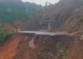
Embankment Failure: The breaching of the Mora Singra guide bund at Atichuk and the “ULFA Embankment” at Aamtola in 2025 inundated 243 villages and National Highway 15. Similar breaches occurred in 2008 (10 locations, 7.8 km collapsed near Ujani Khamti) and 2017 at Noinpur (July 9, 2017, 10:00 PM, water level 95.95 m vs. danger level 95.02 m) and Bogolijan (July 10, 2017, 10:45 PM). Between 2002 and 2014, nearly 43 breaches occurred due to overtopping, erosion, and poor maintenance. Inadequate embankment gradients (1:2 riverside, 1:3 countryside) and incomplete geo-mattress coverage, issues persisting in 2025, worsened the situation. Embankments also confine flow, increase siltation, and raise riverbeds, reducing channel capacity and exacerbating breaches.
Historical Context of Poor Dam and Embankment Management
The Ranganadi’s flood history, 2008 (695.20 cumecs), 2017 (1,412.57 cumecs), and incidents from 2009 to 2015, reflects systemic flaws, identified as follows:
Inadequate Inflow Forecasting: Limited rain gauges and a single stream gauging site 10 km upstream, with hourly inflow measurements (updated every three hours), fail to capture the river’s flashy nature.
Lack of Flood Cushioning: The PHEP, not designed for flood control, prioritizes power production and maintains the reservoir at 567 m, leading to sudden high releases.
Poor Warning Systems: In 2017, NEEPCO’s SMS alerts provided only 2–2.5 hours of lead time, and eight sirens installed in Assam (2009–2010) were partially non-functional due to power and manpower shortages. Residents reported no siren alerts in 2017 or 2025.
Sediment Management: Sediment deposition in the river’s central channel forces flow toward embankments, increasing breach risks, as seen in 2008, 2017, and 2025.
Responsibility for the Downstream Havoc
NEEPCO bears primary responsibility for the 2008, 2017, and 2025 floods due to:
* Inadequate Warning Systems: In 2025, warnings were insufficient, as in 2017 (2–2.5-hour SMS lead time) and 2008 (no effective alerts). Non-functional sirens and lack of downstream coordination exacerbated the issue.
* Excessive Water Releases: The 2025 release (1,250 mm gate opening), 2017 release (1,412.57 cumecs), and 2008 release (695.20 cumecs) exceeded safe river capacities due to poor inflow forecasting and reservoir management.
The Lakhimpur district administration shares secondary responsibility, as embankment strengthening and siren operationalization were not fully implemented by 2025, perpetuating vulnerabilities seen in 2008 and 2017.
The May 31, 2025, Ranganadi flood, like those in 2008 (695.20 cumecs, 22 deaths) and 2017 (1,412.57 cumecs), was a preventable disaster driven by NEEPCO’s mismanaged dam releases, heavy rainfall, and inadequate infrastructure. The 2017 IIT Guwahati study’s recommendations to improve inflow forecasting, operationalise sirens, and upgrade embankments were largely ignored, perpetuating vulnerabilities. NEEPCO’s primary responsibility, compounded by administrative and policy failures, demands urgent implementation of these measures to protect downstream communities in Lakhimpur.
(The writer can be reached at kkchatradhara@gmail.com)