


By Danny K. Rajee
It was just past midnight when I felt my bed shift. Not the rolling, drawn-out kind of shake that gives you a moment to think — this was sharp, abrupt, like something massive had exhaled beneath the house. I ran to the doorway. Outside, a neighbour was already in the street, barefoot on the wet tarmac. Neither of them said anything. There was nothing to say.
The tremor — a 4.2-magnitude event recorded in East Khasi Hills in late 2023 — caused no deaths. A few cracked walls, a toppled water tank, the usual three days of anxious WhatsApp forwards. Then, as always, life resumed. “We forget very quickly,” Mr. Lyngdoh, a schoolteacher in Shillong’s Mawlai neighbourhood, told me. “Until the next one.”
The next one, geologists will tell you, is not a matter of if. It is when — and how prepared we are when it arrives.
“The plateau looks calm. But if you study the fault lines, you understand that calm is not the same as safe.”
Meghalaya sits at one of the most seismically restless corners of the Indian subcontinent. The Shillong Plateau, which most residents regard as ancient and immovable, is in geological terms a relatively recent uplift — thrust upward by the same slow-motion collision between the Indian and Eurasian plates that built the Himalayas. Fault lines run beneath the plateau like hairline fractures in porcelain.
A seismologist at the Institute of Advanced Study in Science and Technology in Guwahati, has spent decades studying these faults. He said, “The plateau looks calm. But if you study the fault lines, you understand that calm is not the same as safe.” Districts including East Khasi Hills, West Jaintia Hills, and Ri-Bhoi fall within Seismic Zone V — India’s highest risk category. In 1897, the Great Assam Earthquake, believed to exceed magnitude 8, physically reshaped the landscape here. Rivers changed course. Hills collapsed. An entire town sank.
That earthquake is a century and a quarter behind us. But Shillong has grown enormously since, and it has grown upward — into the hillsides, onto ridges that were once forested, in buildings that predate any meaningful seismic code. Nobody Could not tell me which seismic zone they lived in.
What Shakes With the Ground
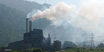
The earthquake itself is rarely the whole story. In a landscape like Meghalaya’s — steep slopes saturated by some of the heaviest rainfall on earth, limestone riddled with cave systems, hillsides already stressed by quarrying and road-cutting — the secondary effects can be as devastating as the initial tremor.
Landslides are the most immediate risk. The road from Shillong to — the wettest inhabited place on the planet — passes through terrain that collapses routinely even without seismic provocation. Deforestation has stripped away the root systems that once held these slopes together. A moderate quake during monsoon season on such ground would be catastrophic. Debris would choke the rivers, and the damage would not stop at Meghalaya’s borders: the Umkhrah and Myntdu drain into the Brahmaputra basin, carrying whatever the hills release down into Assam and Bangladesh.
Then there is the water. Rural Meghalaya runs on springs — the quiet, cold seeps that emerge from limestone aquifers and have sustained villages for generations. Seismic activity can disrupt these underground systems without warning, drying up springs in one area while causing sudden surges in another. Cracked urban sewage lines in Shillong would contaminate what remains. In communities already battling water scarcity in dry months, the consequences could last long after the tremor is forgotten.
In Jaintia Hills, there is an additional, largely unacknowledged hazard. Decades of rat-hole coal mining have left the earth beneath parts of the district honeycombed with abandoned tunnels. What happens to those voids when the ground shakes? Subsidence, sinkholes, and toxic mine water discharged into rivers are all possible outcomes. The Supreme Court banned rat-hole mining in 2014, but the landscape it left behind will carry that instability for decades.
“We cannot keep building as if the ground beneath us is permanent. It has never been permanent.”
Building on the Edge
Walking through upper Shillong on a clear morning, you see the city’s ambition written on the hillsides: apartment complexes cantilevered over slopes, retaining walls of uncertain vintage, construction sites where the bedrock has been blasted back to accommodate another floor. There is money here, and optimism. There is also a great deal of risk.
Meghalaya adopted its building bylaws based on national seismic codes, but enforcement is uneven. “The code exists on paper,” one structural engineer told me bluntly. “Whether it exists in the building is another question.” Heritage homes in the older quarters, built for a different era and a different risk calculation, are particularly exposed. But so are many newer structures, where speed and cost have trumped structural rigour.
A civil society advocate who has campaigned for stricter building regulation in Shillong for over a decade, is not optimistic. “Every time there is a tremor, politicians promise reviews. Then it passes and nothing changes.” She believes the solution lies not only in stricter enforcement but in a fundamental rethink of land use — mapping the city’s actual geological risk and refusing permits in areas that simply cannot safely bear the weight of development. “We cannot keep building as if the ground beneath us is permanent,” she said. “It has never been permanent.”
The Knowledge That Was Already There
There is a tendency in disaster preparedness discussions to speak as though all the relevant knowledge is waiting to be created — new maps to be drawn, new codes to be written, new institutions to be built. But in Meghalaya, some of the most important knowledge is already here, embedded in practice.
Sacred groves — the ‘Law Kyntang’ of the Khasis — have survived for centuries through community protection. They represent not just biodiversity but functioning ecological buffers: forested slopes that hold soil, absorb rainfall, and reduce the landslide risk that a tremor would otherwise amplify. The DorbarShnong, the traditional village governance structures, have demonstrated an ability to mobilise communities for collective ends that formal municipal institutions often cannot match.
The question is whether these institutions will be treated as partners in preparedness — or sidelined, as they too often are, in favour of top-down programmes that arrive after the disaster rather than before it.
“Shops that had been on the left now turned up on the right and vice-versa…The cow had vanished and so had the policeman. A motorcycle had disappeared into a hole in the ground, while a car had mounted the steps of the town hall. A Tonga pony galloped down the middle of the road.” Earthquake, Ruskin Bond
Back in Mawlai, Mr. Lyngdoh has started doing something small but deliberate: talking to his students about earthquakes. Not just the science — the fault lines, the magnitudes, the Richter scale — but what to do. Where to go. What not to do. He does it because nobody did it for him. “When that tremor came, I ran to the doorway because I remembered something from television,” he said. “But my students — they just freeze. They don’t know. And not knowing is its own kind of danger.”
The hills will shake again. That is not alarmism — it is geology. The harder question, the one that Meghalaya’s planners, builders, and communities will have to answer together, is what will be standing when they do.