


By Dr. Dondor Giri Nongkhlaw
Every nation, every race and every civilisation on earth have their own story. The story of their origin, their expansion, their glorious achievements and of course their decline and downfall. It was a classic case of ‘higher they are, the harder they fall’. For example, in our own lifetime, we just heard and seen the decline or the disintegration of the world’s biggest nation, the U. S. S. R., into many sovereign states, so also it was the case of the British empire, the empire where the sun never set.
How and when the British came into contact with our forefathers is not exactly clear. But as far as can be made out from history books (Pemberton, Capt. R. B.-Report on the Eastern Part of India), it appeared that the British first came into contact with our ancestors in the later part of the 17th century after the acquisition of the Dewani of Bengal in 1765. Their expansionist ideas brought them in closer contact with our ancestors after defeating the Burmese and the annexation of Assam by the Treaty of Yandaboo. After they had established their presence in Assam, their attention was focused into our mountainous lands.
When the British officers first reported about our land, they described our land as Cossyah mountains or Khasia mountains. Later, when they had exercised control over it, they relegated the term into Khasi hills and ultimately into Khasi and Jaiñtia hills which clearly reveal their divide and rule policy. Now, by definition, mountains are defined as high sections of land with elevations as high as 1000 metres and above, whereas hills are those intervening sections of land between the mountains and the plains. It is, therefore a paradox, that the egoistic British called their hilly tracts, the Pennines, as mountains whose highest point, Mt. Cumbrian, being 978 metres only, which is half the height of Shillong peak, 1965 metres. Beside this fact, they even annexed sizable portions of our lands that are presently in Garo hills, Assam and Bangladesh and the infamous Radcliffe Boundary Award Commission demarcated the boundaries of our land with the then East Pakistan, (now Bangladesh) around the base of the War mountainous country only.
Now why the British should focus their attention into our mountainous land? The fact was, according to historical records, to construct a route right across the western Ri Khasi to connect the British territories of Assam and Bengal. In my fieldwork through the years upto 1998 when I travelled and traced this route on the ground, I discovered the clever and ingenious design of the British as the alignment of this route from Ranigudam to Bholaganj is in a north south direction and was confined in between 91˚ 35̎ and 91˚45̎ east meridians. Which means that this alignment was allowed a permissible limit for deviation to within 10 minutes by considering the topographic constraints which the route has, at places, to cut and run in a zigzag manner so as to maintain a favourable gradient of less than 35 degrees. I found out their ingenious ideas only after taking field measurements and preparation of a map of this route.
The British with their vast world experience in administration adopted a friendly and diplomatic approach when they asked Tirot Sing for permission to construct a route through his territories. Then after two days of heated but diplomatic debate, the Nongkhlaw Parliament (Major White’s account), consented and by the treaty of 30th November 1826, see Pemberton’s account, the permission was granted.
At the initial stage the work went well. Jungles were cleared; tents and camps were set up and pitched conveniently at selected spots. The work then started in right earnest. The bulk of the workforce was constituted mainly of convicts, (Ray, B. Datta-An account of Shillong) and plainsmen of Bengal and Assam. The workforce was splitted into work groups or gangs. One group was involved in jungle clearing, another in digging and earth cutting and still another group was engaged in transporting stones and rock slabs and the skilled groups in laying the stone pavements and construction of culverts and bridges.
The work started early in the morning from 8 a.m. at the sound of the gong with a short respite of one hour for lunch and then again upto 5 p.m. food for the workers were brought to the work sites whereas the British officers returned to camps to have their food leisurely. After the day’s work was done, at the sound of the gong, the workers trekked back to their camps while the British officers lingered for some time more to inspect the day’s work. On arriving at their camps, the workers washed and bathe in the nearby streams and had their meals in groups. Their food consisted mostly of rice and vegetables and sometimes meat and fish. During the day and nighttime sentries were posted to guard and patrol the camps and strict vigilance was imposed. And on sunny days, the Union Jack could be seen fluttering high above the flag post that was planted to the ground in front of the officers’s tents. Later, in the evening, before retiring for the night, all workers were asked to fall in, where roll calls were taken and to hear of their reports of sickness and requirements after which the British national anthem would be sung and the men dismissed for the night.
At such times, meetings of the officers were usually held to review and discuss the problems they encountered. The number of working days lost due to heavy rains and other factors were calculated and progress charts were prepared to know how much progress have been achieved. This was done as progress reports had to be filled and sent to the Government in Bengal. On such nights the officers would take their dinner very late. Outside, on moonlit or moonless starry nights the sentries could hear the sounds of myriad insects like fireflies, crickets and the occasional sounds made by big games like elephants etc., for this area was then an elephant infested country. Therefore, around the camps, big logs were purposely kept burning to keep away animals, insects and snakes.
In the course of the construction work many workers fell ill due to heavy work, big boulders have to be prised loose and rolled down the slopes, snake bites and accidents occurred. In places where culverts and bridges have to be constructed, boulders have to be hammered, chiseled and broken as dynamite was unknown then. Such manual work was too much for the constitutionally weak plainsmen. Besides, harsh and unfamiliar terrain and unhealthy climatic conditions where malaria abounds made the workers monotonous and less energetic. But in spite of all these, the route slowly took form and the distance covered was plotted on a map inch by inch and mile by mile.
The route from Guahati passed through Pandu to Mirza then to Ranigudam, where monoliths can still be seen. This stretch of the route was then full of marshes and swamps;thus, earth fillings and embankments were made. A little south of Ranigudam the route then passed over a small stream, Umtyrphi, then along the western flank of a hill, Lum Marok. At the southern base of this hill there was a hot spring. The route then passed through a small low-lying valley where it then crossed the headwaters of Umsak stream. From this point, the route turned east for about one and a half mile in a winding manner. After crossing this distance, the route turned slowly in an S manner along the western flank of a small spur and skirting very gently around the headwaters of another small stream that flows to the Umsak. From here, the route continues along a flat looking ridge, Domstar, till it touched the headwaters of Umshaid. This ridge, Domstar, till today is a favourite haunt of elephants. The Umshaid forms a natural boundary between Hima Nongkhlaw and Hima Jirang or Mynnar as it was known earlier. From the headwaters of Umshaid, the route follows along its right bank upto a distance of six miles south till it reaches a small hamlet of Umsaw. The gradient on this stretch of the route does not exceed thirty degrees and this was achieved by taking advantage of the available flat river banks and gently sloping nature of the hills. Around Umsaw, the land is flat, where the route then took a left turn and ascends slowly for about three miles along the northern slopes of a conical hill in a south easterly manner till it descends and touched another stream, Umtaru. From Umtaru, the route turns directly south after crossing the Umrit stream uptoDonmati and present Umshohphria. The general elevations at and around Umshohphria ranges between 1000 feet and 1500 feet. Then from Umshohphria, the route climbs up slowly at a gradient of 32 degrees upto a flat hill top overlooking the Umlur stream in the south. The route then descends downsouth for about a mile on a moderately steep gradient till it crosses a small stream to climb up again the slopes to the saddle of a twin peak ridge. From this point, the route descends to cross the Umlur stream then takes a winding turn around the slopes of small ridges that are aligned in a north south direction till it crosses another stream, Umdumai. The route then follows the right sloping portion of an oblong tapering ridge upto Lad Pnar where the lands look flat but the elevations around these areas exceed 2500 feet above m.s.l.
The topography on both sides of the route consists of a jumbled mass of hills which nature had arranged randomly without pattern or direction, which is an indication that this part was subjected to several tectonic upheavals which fractured the underlying rocks. Evidences of such tectonic activities can be seen about one mile south of Umsaw and east of Lad Pnar where faults occur.
The rocks seen here are of the oldest order – the Archaeans, which are found exposed at several places. These rocks spread far and wide. To the south where intervening hills merge with the Nongkhlaw mountains, these rocks are concealed deep below which are overlaid by sandstones forming the Nongkhlaw mountainous tracts. The soils seen here are found mixed with sand in association with shingles and are brown in colour. The soils at many places are friable in nature. Thus, all the water of the rivers that flow through these parts are turbid and muddy and tasteless. The animals that are still found here are deers, tigers, bears and elephants and the big rivers abound with fishes.
This stretch of the route from Umshohphria to the northern slopes of Nongkhlaw is one of the most difficult terrains to work on. The area is crisscrossed by many streams, rivers and valleys, thus making of a route were difficult. The thick jungles, then, with leeches on tree tops, wild animals, snakes and harsh topographic conditions with large exposures of rocks and boulders at many places slowed down the work. Since the British considered construction of this route as a strategic line of communication, they relentlessly pushed and pressed the men to work harder. This attitude of the British brought resentment to the workers; they started to grumble but dared not rise against the might of the British.
So, at nighttime, inside their camps, the workers started to think of a way out to make the British abandon and shelve the construction work. Night after night, many ideas and suggestions were made but nothing concrete came out. Later, in some other nights, when such discussions took place, somebody wily and cunning, gave an idea, an idea to spread a rumour. This idea was apparently approved as it was much safer than killing the British officers in case such a plan backfired. The resentment of the workers was further aggravated by the hospitable disposition of the Nongkhlaw people towards the British, plus the eerie sounds of ‘Ka Bom’ made on religious and festive occasions and the sudden appearance of the Nongkhlaw warriors at worksites as if from nowhere, with their naked sabers, put fear into the hearts of the plainsmen. And by tradition, the plainsmen never dared to venture into this mountainous land as our ancestors were viewed as ‘fierce marauders who killed and plundered’. With such preoccupations on their minds, the route progressed slowly from Lad Pnar across Umñiangriang, Umlangdi and across the Khri river upto the mountainous slopes of Mawïong. And when the route started to climb higher and higher in a zigzag and winding manner, camping and tenting sites were shifted uphill above Mawïong. The British by this time had constructed bungalows at Nongkhlaw for their headquarters.
The opportunity to spread a rumour presented itself when some workers were given a day’s off on weekly markets at Umsaw and Nongkhlaw. The rumour that was spread was that ‘on the completion of the route the natives would have to pay taxes. At first, the native people did not take it seriously, but as time passed the rumour became more persistent. The people then started asking, ‘sha kane ka dohliehkanphah siew khajnaïangi?’ This was too much for the freedom loving people – a people who were never subjugated were enraged. Thus, on such a situation, those other elders who had earlier opposed the granting of permission to the British got a chance to rebuke the other elders for such a blunder. Secret meetings were then summoned and discussions held. The outcome of the discussions was to kill all foreigners.
Meanwhile, the workers, the soldiers and officers went about their work as usual and were unaware of the developments that transpired at Nongkhlaw. Then on a predetermined day the Nongkhlaw warriors along with Tirot Sing and his ablest Commander, Monbhut, struck.
At this juncture I will quote from “Up the Burrumpooter: the opening of the Upper Assam Valley” by Charles Allen and is given in italics, “on the morning of the 4th of April 1829 the occupants of the Nongkhlao sanatorium woke to find the bungalow surrounded by some 500-armed Khasi warriors. Fortunately for David Scott he had set off for Cherrapunjee only the day before, so it was Richard Bedingfield, the older of the two officers, who went out to talk to the crowd. According to the account published in the Bengal Observer, he was given no opportunity to find out what the disturbance was all about.
They immediately seized him, and after tying his hands behind his back and cutting the tendons of his legs, commenced shooting at him with their arrows. It is said that he told them, if it was his life they wanted, to kill him outright at once, which they accordingly did and, cutting off his head, placed it on a rock.
The killing of Bedingfield was over before Burlton could do anything to prevent it, but he quickly mustered a few sepoys who were quartered in the bungalow and successfully repelled the first Khasi attack. His little party held out ‘in gallant style’ for the whole of that day and the night. But at dawn on the following day the Khasis managed to set the roof of the bungalow alight with firebrands and the defenders were forced to make a break for it. Burlton and his men charged out in a body and by keeping up a constant fire, were able to hold the Khasis at a distance. They began to make their way along the roads towards Cherrapunji, still keeping together and successfully preventing the Khasis from losing off their arrows at close range. Eventually their luck ran out; a sudden shower of rain came down and wet their powder, making their firearms useless. One of the first to be slaughtered was Philip Burlton: He was in the act of extracting an arrow from his wrist when he was cut down”.
This event came to be known in history as the NONGKHLAW MASSACARE of 1829. David Scott himself was lucky to escapeas he had set off for Cherrapunjee only the day before. “The unexpected departure of Mr. Scott from Nongkhlaw for Cherra saved him from the dreadful fate that befell his valued friends – and some days have elapsed before he was made acquainted with the afflicting reality” (Pemberton, Capt. R.B., – Report of the Eastern Frontier of British India). The Nongkhlaw Massacre then triggered a series of a long-protracted warfare where neighboring Khasi States also got involved. Later, with the surrender of Tirot Sing in 1833, the mountainous land became quiet and construction work of the route was then resumed.
Thus, the route continued from Nongkhlaw via Mawlyntriang across Umkhowai, Umshorshor, Nongrmai, Madan Sohphoh, Mawshut along the Urksew stream, Langstiehrim, Lum Marlong, Mairangthem thence across Umsohkhlur also known as Umsaittympew to Mawlong and across Wahlakhaw to Nongbri, Wah Lulu, Manai, Mawmeri, Kynringumdishit, Mawmaram, Umsohphreit to Sohïong, Mawdngung and across Mawkohtep to Rangshken, Umtyrñiut and across Umrina, Them Kubin, Phud ka briewuptoMawphlang. The gradient of this route from Nongkhlaw to Mawphlang does not exceed 30 degrees. The stretch of the route from Mairang to Mawphlang was constructed by Shan Manik, Syiem of Mylliem.
Sadly, this historic route right from Gauhati through Mirza, Ranigudam, Jirang, Patharkhmah and Umshohphriaupto Nongkhlaw no longer exist but at places have been superimposed by modern metalled road. However, traces and remains of this route, for short distances only can be seen at Lum Marlong, Umkhowai, Wahlakhaw and Nongbri then at Manai, Sohïong and Mawphlang. And nearly all suspension, iron and stone arch bridges throughout the route from Ranigudam to Sohïong have been destroyed.
The topography from Nongkhlaw to Mawphlang represents a wavy and an undulating character. The many streams and low valleys that interspersed the area on both sides of the route gave rise to innumerable flat-topped mounds which diversified greatly one from the other in form and size. In fact, this stretch is far more open and spreading. Waterfalls that are seen along this stretch take more the form of rapids. The rocks that are seen here are slaty and gneissose rocks. Veins of granites are seen at Mairang and Wahlakhaw. Sandstones appeared from near Wahlakhaw to Sohïong where bursts of granites are again seen. Khasi greenstones are seen north west of Mawphlang and at Lum RyngkewMawlong.
The only stretch of this historic route that is still intact and can still be seen today runs from south west of Mawphlang up to Lad Mawphlang on the Shillong –Cherra Road. From Mawphlang the route runs in a southerly direction on a gentle gradient for a distance of about 2 kilometers. At about half this distance on a very straight stretch of the route, on the right side, there still stand a stone structure known locally as ‘Ka Kor Shongthait’ specially constructed as a resting place. Then just at the point where the stone pavements start, on the right-hand side, there still remain the grave of a child where three standing monoliths are erected with the middle monolith as a tombstone where these words are inscribed, TO A CHILD FONDLY CALL’D CAMILLA, “SOFT SILKEN PRIMROSE FADING TIMELESSLY” 1843. The grave with a central monolith as tombstone suggests that the child was born of a Khasi mother and British father. And according to my research the father was probably one Mr. Jones, a Surveyor of the British Survey of India, who was instrumental in the alignment and direction of the route.
The route then descends slowly in a zigzag manner downslope of a steep mountainous slope where the route then crossed a small stream, Wahkyngkienwar that emerged from the Mawphlang Sacred Groves and the remains of an iron bridge can still be seen. From the iron bridge, the route runs in a slow turn on flat but narrow corridor till it reaches a narrow point of the Umïam-Mawphlang river where a suspension bridge exists.
After crossing the suspension bridge, the route then follows the left bank of the Umïam-Mawphlang river. At a distance of 36 feet from the suspension bridge on the left, there is a flat but inclined rock at an angle of 76 degrees, measuring 4 feet by 6 feet. This rock is significant as it is etched by ripple marks which indicated that this area was an area of intense orogenic activity. These ripples marked rock is missed by every hiker, trekker and even field scientist failed to mention it.
From here the route then runs on flat level ground but in a curve manner till it reaches Wah Tham, known as Umsaw in the upper reaches, where the remains of an iron bridge can still be seen (but now no more). Had the route completed before the war of 1829 this stretch of the route offers the best place for ambushing the Britishers. From Wah Tham the route slowly climbs up a steep mountainous slope in a winding and zigzag course at an angle of 32 degrees to culminate on the summits of small mountain ridges. From between these ridges the route then passed through an undulating topography, where there are two villages, Laitsohma and Mawbeh. The route then touches the headwaters of Umjaut and follows its right bank for about 3 kilometers. The natural beauty around these parts is simply magnificent. The vegetation seen left and right of the route are mostly of the tropical type but pines are non-existent. Thick and impenetrable forests are seen on the higher ridges. The Umjaut is a small mountain stream that rise west of Step Lakrai village, the route continues to follow the Umjaut on flat level surfaces for about 3 kilometers and at about half this distance we can still see a retaining wall on the right bank that still stand firm testifying to the skill and workmanship of our ancestors. Around this section the remains of rocky water trough for watering the horses are also seen.
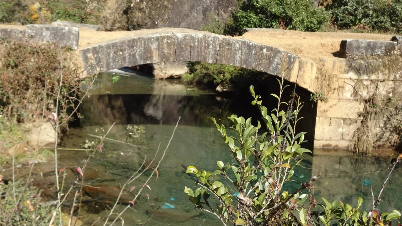
This very section of the route is the most ideal picnic spot and is probably the favourite resting spot of many a traveller. After some distances, the Umjaut turns to the right where there is a beautiful stone arch bridge which can carry a load of maybe 20 tons. From this stone arch bridge, as the route continues, the landscape to the right is cut by low valleys bounded on the west by a ridge known as Mawklang. From the top of this ridge, we can see two beautiful villages, Pyrda and Kukon. After crossing the Umjaut for a distance of about one and a half kilometer, to the right of the route there is the legendary stone, Mawnguidbriew. The route keeps on continuing on level ground and it goes on till it emerges at a place which resembles an arid topography. At this point rocky bluffs and overhanging cliffs with small waterfalls are seen and cover a wide area. The gradient of the route throughout is very low. A small stream, formed by these waterfalls, flow to the west where it meets the Umjaut at a point where the landscape is strewn with big boulders.
The route then runs straight into a pass then slope gently to the south. At the head of the slope there is Ka Kor Shongthait. From this point the world renowned Wah Umïong can be seen and the route descends down the slopes till it crosses the Wah Umïong where there is another stone arch bridge. Standing on the bridge we can have a panoramic view of upstream and downstream of Wah Umïong. This river emerged from Dympep and for most of its length, it flows on greenstones bed. From the arch stone bridge of Wah Umïong, the route runs on gentle gradient by skirting the western flank of a steep ridge in a winding manner where it then ascends another hill slope till it meets the present Shillong-Cherra Road at a place known as Lad Mawphlang.
From this point the route runs in the south westerly direction with some bends on a gentle gradient till Sohra. From Lad Mawphlang to Cherra the landscape is more open and spreading which is an indication of a plateau and the route continues along Sohrarim, Mawmihthied, Mawkabor, Siatkwah, Laitryngew, and Laitmawrap till Sohra. From Sohra the route continues through Pomsohmen, Nongsawlia and Dukan with a very gentle gradient. The topography from Lad Mawphlang to Sohra is highly undulating and the type of rocks seen is sandstones, conglomerates and clay. From Dukan it runs south through Saitsohpen, Mawpun ka Rtiang, Nongthymmai and Mawsmai, the landscape is more or less flat and one can see the wonderful KshaidNohsngithiang from this route. From Mawsmai the route continues south to Laittyra where we can still trace of this route upto Sohbar and it takes a winding and zigzag course and the elevations start dropping sharply right from the vicinity of Mawsmai – Laitïam. The landscape around these parts is steep but the route is cut in such a way that the gradient of the route is maintained at around 35 degrees. From Sohbar the route turns south west through Theriaghat and continue uptoBairong bazar to Bholaganj and Pandua where the elevation is a mere 220 feet.
Theriaghat, Bholaganj and Pandua are located at the base of the War country. Theriaghat is navigable by small boats upto Pandua. From Bholaganj the route followed the right bank of the Umsohryngkew (Dhalai Gang) to Pandua upto the station of Companyganj which is situated at the confluence of Umsohryngkew and Rupa Tylli. The landscape in these parts is flat and is full of marshes and swamps. Thus, embankments were constructed from Pandua to Angajurupto Sylhet. Angajur was the territory that belonged to Hima Sohra gifted by the Jaiñtia Raja and is located about 9 miles north west of Sylhet.
This then is the story of the route, known as the David Scott’s route. It was the route that changed the history, the political and religious structure, the economy and social life of the Khasi people. As of today,i. e. in 1998, the part of the route from Mawphlang to Lad Mawphlang, a distance of about nine miles, is as good as it was 165 years ago.
Trekking through this stretch, those with a sense of history and patriotism can still breathe the air and drink the same water that our ancestors have done. With such thoughts in my mind, I looked to the western sky where dark clouds slowly swallowed the daylight. And as I tread along the ancient earth to return home, my mind goes back to those 165 odd years trying to figure out and relive the events of those days and the memory of the trek will linger on forever, for this is then the WRITTEN STORY of the route that was made by sweat, blood and tears. And the only tribute that can be awarded to the memory of all those warriors who fought against the British and to those who had a tryst with the construction of this route is to observe the 4th of April every year as the Khasi National Awakening Day and by preserving the route and the environs on both sides from Mawphlang to Lad Mawphlang as a fitting memorial to their memory.
IMPORTANT DATA OF THE ROUTE
- Total length – 105 miles
- Alignment – north to south
- Number of suspension bridges constructed – 20, only one or two now remained.
- Number of stone arch bridges constructed – 16, at present about only 6 remained.
- Present status of the route – only about 6 % remain intact from Lad Mawphlang to Mawphlang and Laittyra to Sohbar.
- Width of the route 8 to 10 feet.
(The writer was a former Surveyor, Survey of India and former Head, Department of Geography Synod College)