


By Dondor Giri Nongkhlaw
One hundred and thirty-seven years ago, Shillong, the Capital City of the Undivided Assam, and now the Capital of Meghalaya was non-existent. The evolution of Shillong from small and scattered hamlets into a big city of today owes its origin to the British Administration of Assam. Today, Shillong is a growing city, as it grows it is beset with problems of space resulting in the mushrooming growth of unplanned settlements plus a host of other problems like sanitation, water supply, narrow roads, traffic jams etc. However, the jovial and jolly character of its citizens offsets all these. Thus, its reputation as a centre of learning, as a health resort and centre of social and intellectual interactions spread far and wide.
Many world-famous personalities have visited, stayed and some of them died here. The names of such famous personalities may be mentioned here are Pope John Paul II, Verrier Elwin, the Anthropologist, E.P Gee, the Naturalist, C.V Raman, the Nobel Laureate Physicist and Rabindranath Tagore, the Poet Nobel Laureate. Even the modern science of Seismology owes its origin to the thorough studies of the Shillong Earthquake, 1897, by the famous Geologist R.D Oldham. Today Shillong has adapted to the western lifestyles in the backdrop of native traditions and culture in spite of its being a land – locked city
Nomenclature: The name of Shillong is derived from the name of the mountain – top of the state originally known as U Lum Shillong. This mountain -top is believed to be the abode of the God known as U Shulong, literally, ‘The one who exists by himself’. The original name got corrupted into Shillong to suit the British way of pronunciation and spelling
Genesis and History: At the end of the Anglo – Khasi wars in 1832, and with the arrest of U Tirot Sing, the King of Nongkhlaw state, the headquarters of the British Political Officer was shifted from Nongkhlaw to Cherrapunji in 1835. But due to heavy rainfall and the out- break of the Pnar rebellion in 1860, Cherrapunji proved to be inadequate both in terms of climate and location. The search for a better site then began in 1858 Captain Rowlatt, the then Deputy Commissioner of Khasi and Jaintia Hills District, appointed a Committee for the selection of a new site. After much searching, the committee recommended Ïewduh and the adjoining lands as suitable for the new site. Soon after in 1866 the headquarters was shifted from Cherrapunji. Shillong then gained impetus when it was made the political headquarters of Assam Province on the 20th March 1874, with Col. R H. Keating as the first British Chief Commissioner. But in 1905, the province was reorganised and Bengal was divided. The newly created provinces Eastern Bengal and Assam came into existence with Dacca as the capital, though Shillong remained as the summer capital. In 1912, Bengal was reunited and Assam again became the Commissioners’ province with Shillong as the capital. With the Government of India Act 1919 and further reorganization, Assam was made the Governor’s Province and Shillong became the capital of the new province with Sir Nicholas Dodd Beatson Bell as the first Governor of Assam. Shillong remained the capital of Assam till 1972 when Assam was reorganised for the creation of Meghalaya.
The Geographical Landscape: No human activities whatsoever can ever exist anywhere on the surface of the earth without the geographical landscape. The geographical landscape in terms of its physical attributes largely determines and shapes many aspects of man’s culture and his cultural activities. Therefore, we have to know and understand the physical settings of Shillong as these have a controlling effect on its growth.
Location and Extent: Shillong is located between 25° 6′ north latitude and 91° 9′ East longitude with an average height of 5000 feet or 1520 above M.S.L. Its present geographical area is approximately 120 square kilometres.
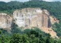
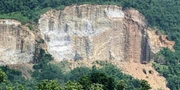
Geology Tectonics and Rock Types: From the examination and interpretation of fossilized remains and rock types which I had collected, some aspects of geology, tectonics and rock groups can be inferred. Plant fossils were collected near Shillong Peak and were found in a layer of rocks at an altitude of 6112 feet inclined at an angle of 40°. These rocks show signs of early metamorphism. The ripples-marked rocks were found at Laitkor Rngi at an altitude of 6107 feet. Then a thin layer of conglomerates were found near Ummawlong, Lawsohtun at a height of 5800 feet. These evidences, the plant fossils, the ripples – marked rocks and the conglomerates tell us that Shillong and its surrounding areas were once under the sea and were uplifted to its present form by slow, gradual and sometimes violent upliftment as indicated by the presence of igneous rocks. The rocks seen in present day Shillong are the Khasi greenstones in the Umkhen Valley and Mawiong, the granites south of Shillong Peak and north of Umiam Khwan near Diengiei Peak, the quartzites are found exposed at various localities particularly the Laitkor area, the sandstones found exposed at Mawblei, Nongrah, Lawjynriew Langkyrding etc. The conglomerates are seen on a thin layer in one location only near Ummawlong, Lawsohtun
Soils: The soil of Shillong, apparently due to the nature of topography and vegetation varies from place to place In the Dymmiew area covered by the Laitkor, Riat Laban and Upper Shillong Protected Forests, the soil at places appear black in colour with abundant organic matter especially where evergreen trees dominate. In areas where Pine trees dominate the soil is lateritic and red in colour. However, at many places the soil characteristics vary in terms of colour, texture and content. Thus, we can see in Shillong other types of soils like the brown soils, loamy soils, and clayey soils. In the low-lying areas of the isolated flat lands such as Pynthorbah and Langkyrding the soil is black and fertile and were once rich agricultural lands.
Vegetation: In all sincerity I find it difficult to describe the nature of vegetation cover once seen in Shillong. But based on soil studies it appears the vegetation was of the evergreen types which include trees known in Khasi as u pyrshit, diengngan, diengsning, diengtyrnem, diengsohliya, diengsohlang, diengtiewsaw etc. And these were probably profuse seen once. The type of vegetation that once grew in Shillong is testified by a place named Oakland where Oaks were once abundant and the Shillong Botanical gardens preserved most of the tree species found in the early days of Shillong. U Soso Tham, a Khasi Poet, has vividly epitomised the grandeur of a diengsning (Oak) at Umjasai in his poetry.
Animals: Natural habitats of animals have been greatly disturbed throughout the developing and evolutionary history of Shillong. Animals that were seen in Shillong in its early days were deers, stag, bears, monkeys, foxes, leopards and clouded tigers, squirrels, pheasants. Today, occasionally we may encounter foxes, leopards, snakes, squirrels and pheasants, that too only in the Dymmiew area. However, birds known locally as Kbeit, Simtung, Puhwieh, Langdkhur, Paitpuraw, Mrit, Lomi etc, are still seen. Migratory birds like the fruit eating flying foxes or bats are still seen and are still an annual winter phenomenon. Aquatic animals have long been wiped out. But in untouched water bodies like Shalynnai and Dohthli (Channa Sp) are still seen in the Wahkdait and Langkyrding streams, land tortoises known as ka Phraw and crabs are still seen in the water bodies of Ka Dymmiew.
Climate: The Climate of Shillong is that of the sub-tropical mountain climate type and is referred to as humid mesothermal thermal climate in empirical classification. The annual rainfall ranges from 2000mm to 2800nun. Mean annual temperature is in the range of 16 – 18°C. Of late, Shillong seems to have acquired an extreme type of climate. In winter temperature drops dramatically to minus 0° C., whereas during summer the temperature sometimes exceeds 21° C. With the coming up of concrete buildings in a congested and unplanned manner and the increase in the number of vehicles, heat islands in the central part of Shillong are found to occur in summer. Winds, sometimes destructive, like the one in 1989 where houses and trees have been uprooted and people killed, blow fiercely during March and early April and then in September to October. Cloudiness appears during the monsoons but in January or February the sky appeared devoid of clouds except for u Phriang jarut. Two local factors influencing the climate of Shillong are, ka Dymmiew Shillong and the Barapani reservoir. Ka Dymmiew or the Protected Forests act as a heat sink as well as a sink for pollutants of Shillong and have a soothing effect on the local climate. The Barapani reservoir is responsible for the cloudiness and occasional showers during November and February. In winter, frost is a common winter phenomenon.
Topography: Topographically, Shillong can be said to comprise of flat lands, flat mountain, cliffs, precipitous slopes, mounds, undulating topography which comprise the uniform, gentle, convex and concave slopes, valleys, gorges and spurs The highest part of Shillong is the Shillong – Kynton Sngi Range with an average height of 6200 feet. The undulating topography covers the whole of Mawlai right from Umjarain to Ïewrynghep and Nongkwar which ends abruptly into perpendicular cliffs of the Sunapani along the Wah Umkhrah upto Wah Ro Ro. From Nonglum and Mawroh the undulating nature ascends gradually to form the flat level lands of Pynthorbah, Langkyrding and Umkhrah where there is a steep climb to have another undulating feature covering Nongmensong to Happy Valley. However, Jaiaw, Riatsamthiah, Wahingdoh and Umsohsun have a moderately to steep topography, Mawkhar upto Ïewduh is undulating in appearance. The Mawprem area is characterised by moderate to steep slopes. The area between Umkhrah and Umshyrpi is highly undulating whereas the whole of Nongthymmai area can be said to have moderate to steep slopes along with Madanrting. The Laitumkhrah area except Nongrimmaw and Nongrimbah, is also of undulating nature. The whole of Malki is hilly with steep slopes. Such topography is also seen in the Risa and Cleve Colony area. Laban is another area covered by steep slopes but the undulating nature is again seen in the Lawsohtun area.
Drainage: Shillong is drained by two major streams, Umshyrpi and Umkhrah. The source of Wah Umkhrah is the Demthring originated from Nan Syiem, Laitkor. The Demthring is met at a junction in the Rynjah Lapalang area by another stream, Umnongrah which is again fed by Phud Pambriew, Phudbri and Umkoi of Nongrah, Phud Mawdamob and Wah Tepthoh of Happy Valley From the Demthring junction at Rynjah – Lapalang, the stream then flow by the name known as Umpling. The Umpling is fed by Wah Nuid of Mawpram and Umshyngiar of Lumdiengmet. From the Umpling bridge, the Umpling flows along the L – Shaped fault line where there is quartzite to form a waterfall known as Nohkaliar or Spread Eagle Falls. About 300 yards downstream it is joined by another stream Wahkdait, the Wahkdait is also known as Wahktieh and Wahnongkynphoiñin its sources. From the Wahkdait – Umpling junction Umpling takes a meandering U-Shape. From this point the Umpling flows slowly till it meets the Wah Nongthymmai at Demseiñiong. It is from this junction that the name Umpling disappears and it is then known as Umkhrah. The Umkhrah then meets Wah Pamdngiem near Sawphorlong, as it flows it meets the Umdiengsning of the Wards Lake and Oakland at Madan Koidi. Further downstream it then meets the Umsohsun Umsohsun has its sources behind the State Central Library where it is joined by Umkseh of Lady Keane College and Umdiengngan of Thembijoi. The Umsohsun is also joined by a stream, Wah Lakadeng that originates from Lum Ïewduh. The Umkhrah then flows along a winding course descending into waterfalls known as Sunapani where it meets the Umshyrpi to form the Wah Ro Ro. The smaller streams that first form the Umshyrpi are the Umkashi and Wahdienglieng, they meet together at a point now known as Farm Hordel and then flows by the name Umshyrpi. This stream meets Wahkdait at Dhanketi and Umiewrynghep that originate from Lummawrie at Woodland Hospital. After the Malki Playground, the Umshyrpi then meets the Um Rim near Crinoline Swimming Pool. As it flows in a winding course it meets Um Shaw Shaw and Umkynrud of Lumparing and Laban. At Oxford point near the cross roads to Kench’s Trace it meets Umsohkhlur and then further down it meets Umjasai. From this Junction it flows in a winding course taking a nearly round turn at Umshyrpi where it then cascades downstream to form two waterfalls known as Bishop’s Falls and Gunner’s Falls (Kshaid Lynnu). The Umshyrpi is also joined by two other streams known as Ummawpdang and Umsohlang of Nongkseh and Umlyngka. Umshyrpi meets Wah Umkhrah at a steep riparian point where it is then known as Wah Ro Ro. Today these streams can no longer be called streams in its true nature but are merely sewage systems with all types of pollutants imaginable.
To be continued…
(The writer is former Head of the Department of Geography, Synod College, Shillong)